Through the Liberia Strategic Analysis (LSA) project, Social Impact (SI) provides innovative analytical and advisory support to improve the effectiveness and sustainability of USAID/Liberia programs. We are identifying lessons-learned from past experience, providing research and analysis on the Liberian development context, and assisting USAID/Liberia to adapt its programs based on this knowledge.
So what does this look like on the ground? Here are a few highlights of our work:
Preparing for the 2017 Liberian Presidential Election
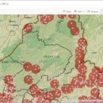
Assessing the security context
The SI team developed and delivered a set of monitoring and evaluation tools to help the USAID Mission prepare for the upcoming presidential election. SI assessed the electoral security context and created a system for ongoing media content analysis throughout the election season. The team helped form a community of practice with Liberian development experts to use the data to engage in knowledge sharing and planning around election security. This is enabling USAID and implementing partners to adapt to shifting political dynamics in real time. It is especially valuable in an environment where misinformation can mobilize violence. Transparent elections are critical to a peaceful transition in leadership.
Developing electronic election observation
Mapping communication capability during electoral events
SI is leading electronic election observation for the U.S. Embassy Observation Mission. LSA will create an electronic form and train teams of volunteers to use it for data collection. As the data is being collected, LSA’s GIS Experts will analyze the data and create interactive maps for observation data visualization. The training will enable volunteers using tablets to remotely upload real-time observation forms to a cloud-based collection point.
The collection of electronic observation data in real-time will allow the U.S. Embassy Observation Mission to report on data collected about polling centers while volunteers are in the field observing actual election day events. There will be an immediate digital record of observation data. This will also facilitate more efficient analysis and data visualization. The real-time data collection and analysis will enable the U.S. Embassy to assess the conduct and quality of the election process in a timely and precise manner.
Expanding the use of evidence for decision making
Using remote sensing to measure infrastructure impact
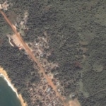
Satellite Baseline image of Edina Road
Lack of rural transport infrastructure is a major constraint to agricultural development and economic growth in Liberia. USAID is working to rehabilitate farm to market roads in certain counties of Liberia. SI will conduct enhanced monitoring of USAID’s rehabilitation of the Compound 1 – Edina Road using
spatial imagery. LSA will take images of the road and the surrounding area through remote sensing at several points in time and measure the changes that occur through spatial analysis. The resulting data will help identify the changes that can be attributed to USAID’s work.
Examining innovative financing for health sector development
LSA recently completed a three-phase evaluation of USAID’s largest government-to-government funding mechanism in Africa – the Health Sector Fixed Amount Reimbursement Agreement. The results will have implications on how USAID moves forward with these types of funding mechanisms globally.
This piece was originally published by the Professional Services Council.