Urgent action on water and sanitation is key to tackling global poverty. New World Bank research, WASH Poverty diagnostics, shows that in Bangladesh, E. coli was present in about 80% of water taps sampled, a similar rate to water scooped up from ponds. In Ecuador, 24% of the rural population drinks contaminated water; 21% of children are stunted and 18% are underweight. In Haiti, access to improved sanitation is stagnant at 33% while access to improved drinking water sources has declined in the last 25 years. The same study also shows that in Nigeria, over 60% of the rural population live more than 30 minutes away from a working water source.
While these findings are alarming, the reality on the ground may be even worse due to lack of granular data covering the entire country at its lowest administrative level. However, using new geospatial data may help improve understanding and therefor targeting improvements in access to water.
The challenges of using household surveys to study access to water
Water and sanitation programs are frequently designed based on findings from representative household surveys, where households report their own access to water. However, it sometimes becomes difficult for policy makers to get a holistic picture for targeted interventions using household surveys when some parts of the country are inaccessible due to remoteness or threatened by security issues. In those cases, executing a household survey for a potential water and sanitation project becomes costly or unfeasible. To design targeted policies in such situation, alternative approaches can be crucial as second-best strategy.
Nigeria, for example, is one of such countries. In 2015, the National Water and Sanitation Survey (NWSS) conducted a country wide household survey supported by the World Bank with particular focus on water and sanitation. This household survey was complemented by water point and scheme surveys, and public utility surveys. Although the survey covered every local government units across the country, the North east region, particularly, Borno and some parts of the adjacent states were not thoroughly covered due to civil unrest and security issues. Many households moved out of the state, water schemes and points were destroyed, and security concern was so grave that conducting a meaningful household survey in those parts of the country was almost impossible.
Using new data to understand access to water
In a recent collaborative study, I joined with water experts from the World Bank Water Global Practice; the University of Maryland School of Public Policy; the Imperial College of London; and the Big Data Institute within the University of Oxford’s Nuffield Department of Medicine to investigate how out of sample geospatial data could be used to model access to water in Nigeria. The study used a predictive approach to generate fine-scale maps of each water and sanitation indicator across Nigeria, based on a body of statistical theory known as model-based geo-statistics (MBG).
With the use of spatially-detailed estimates, the study provides a new set of important information to support the targeting of programs advancing water and sanitation access in Nigeria. It offers more detailed, granular estimates, for tracking progress toward the Sustainable Development Goals.
The team used measures such as brightness of nighttime lights, natural vegetation, aridity, and land-surface temperature and showed that these out of sample geospatial information can be used to predict survey measures like estimated travel time to the nearest functioning water source in a spatially-detailed fashion that can improve program targeting relative to using household surveys alone by allowing for more detailed, granular tracking of access to water and sanitation.
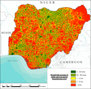
Round trip Journey to water points in Nigeria
Source: World Bank, 2017
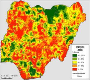
Access to Improved water in Nigeria
Source: World Bank, 2017
With the help of 1×1 km pixel maps the team revealed pronounced spatial heterogeneity in the share of population using improved water across relatively short distances. The study showed that in many cases, the observed relationships matched prior expectations. For example, access to basic and improved water was inversely correlated to an increase in travel time to the nearest water point or scheme. Areas that were more lit up at night (thus more urban) were associated with higher access to sewerage connections and piped water on premises, and lower rates of open defecation.
With the help of such predictive modeling, the study rightly predicts the stark rural- urban differences in Nigeria. It shows that urban areas tend to have high rates of access to improved water, and rates drop off rapidly outside city limits. At the state level, rates span the range from just 23% (in Bayelsa) to 89% (in Jigawa). With this approach, the study finds that largest concentrations of population without access to improved water are found in Kano, Kaduna, and Benue.
See the full paper here.